


 Download(13.63MB)
 1.1.4
1.1.4
 10.42MB
9.3
Walking, Hiking Trails, Landscapes and Monuments. To New Way of Traveling.
Discover the most impressive corners of our geography, without losing a detail and your rhythm. Find hidden landscapes and hidden villages. Know all your stories and legends. Immerse yourself in nature and enjoy all the beauty that surrounds you.
Choose the guide you like the most, download it on your mobile, follow the map even without coverage and receive all information about the places through which the way passes. We propose two types of tours:
Hiking routes
- both official paths and routes designed by our team are included. All of them have been recognized in the field previously, incorporating only those that meet good maintenance, security and interest criteria for the user.
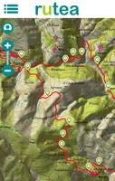
- Each route includes a tour (track), mapping and aerial photography (IGN), as well as information about the area where we are and the points of interest we are going through.
- Once downloaded on the mobile, Internet connection is not necessary (Offline works: all the information on the route is recorded in the memory of our device and the GPS guides us on the map).
- General information on the route is included, as well as distance, difficulty, circular or linear, profile, estimated time, such as reaching the starting point, photographs ... on each route it is specified if it is suitable for the whole family, if it can be done in BTT, if it is recommended to perform with our pets, etc.
- Routes are also included in the center of several cities, including the most important monuments and the most interesting stories of each.
Car routes, motorcycle or bicycle
- carefully designed tourist tours, including the essential points of interest of each area (castles, churches, viewpoints, waterfalls, natural parks, lakes, beaches, bridges, museums, small hiking routes ...).
- Almost all routes are designed to do tourism for several days (a weekend, etc.), but all of them can be done perfectly in a day if we select the points that interest us most.
- Once the route is downloaded we will have all the information on our mobile, without the need to consume data. To get to each point of interest we have the option of guiding us with the GPS on the map (you do not need internet) or use a step -by -step browser (only the data it needs is consumed).
We start with Galicia, but little by little we go up new trails and tourism guides throughout Spain. In addition, the routes are reviewed and updated periodically, completing the information and including new data. All routes are free (both hiking and tourism guides).
Destinations with routes included
A Coruña: Barbanza, Costa da Morte, Bergantiños, Ferrolterra, Santiago de Compostela
León: Bierzo, Ancares, Picos de Europa
Lugo: Coull, Ribeira Sacra
Ourense: Allariz - Maceda, Ribeira Sacra, Ourense, Ribeiro
Pontevedra: Deza, Sanxenxo, Rías Baixas, Salnés, Morrazo, Tabeirós, Caldas, A Cañiza, Cambados, Arousa
Zamora: Sanabria
SYNTHESIS
- Hiking routes and tourist tours in different areas of Spain
- Descriptions, photographs, maps, tracks and data on each route.
- Information about the services you need for a tourism day (restaurants, information offices, etc.)
- Complete tour guide, with detailed explanations at each point of interest.
- Interactive maps of hiking routes work totally offline, without covering.

 Similarity
January 22, 2026
January 22, 2026
January 21, 2026
January 21, 2026
January 21, 2026
January 21, 2026
January 20, 2026
January 19, 2026
January 18, 2026
January 18, 2026
January 18, 2026
January 17, 2026